
Mario Cams, KU Leuven
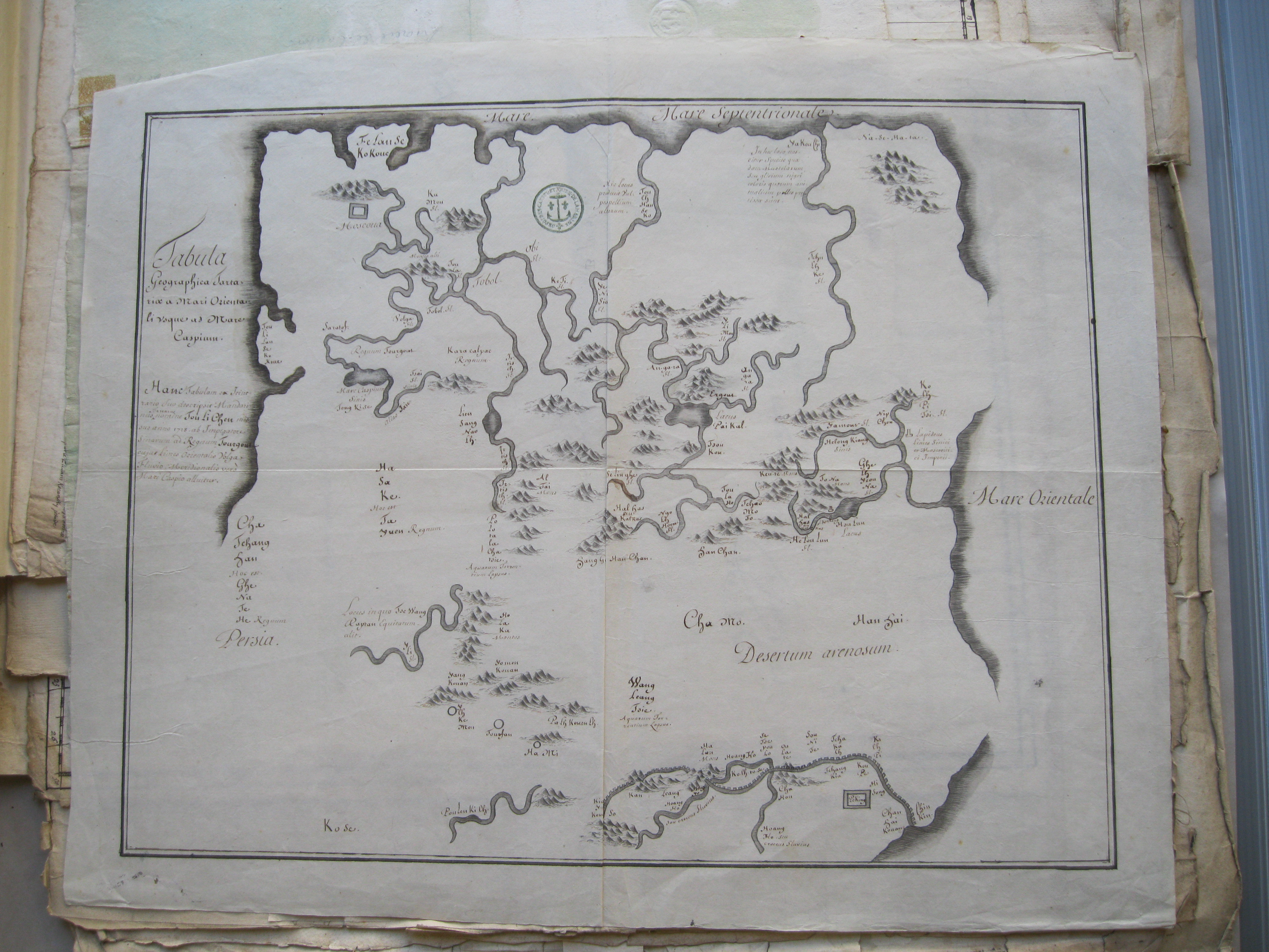
The Département des cartes et plans of the French National Archives preserves a Latin version of the map that is included in the Lakcaha jecen de takūraha babe ejehe bithe (‘Book recording the sending of an embassy to remote regions,’ or Yiyulu 異域錄 in Chinese).[1] This book, published in Beijing in 1723, relates Tulišen’s embassy to the Torgut Mongols, living just north of the Caspian Sea at the time, a journey undertaken between 1712 and 1715. Combining personal anecdotes with detailed descriptions of populations and geographical features, the journal is a rare account of a Qing embassy, sent to a region that lay far beyond the Qing sphere of influence.
From early on, European missionaries at the court in Beijing had been more interested in the possibility of opening an overland route to Europe, hoping for an alternative to the highly unreliable and dangerous sea routes. Seen in this light, it is not surprising that once the French Jesuit Antoine Gaubil (1689-1759) got his hands on a Chinese copy of the text (the original was in Manchu), he immediately translated parts of the journal and sent it to Paris, where it was published as early as 1729.[2]
The Latin map that is kept in Paris has made quite a journey itself. Clearly, it was not sent to Europe by Gaubil. Instead, it must have been one of the non-French missionaries at court who translated it into Latin and sent a copy to Rome. This is suggested in a short note attached to the map, written by Joseph-Nicolas Delisle (1688-1768),[3] a Frenchman and the first scientist to head the School of Astronomy attached to the Russian Academy of Sciences in St. Petersburg:
“Carte du route du mandarin tartare nommé Toulichen envoié en 1718 [sic] par l’empereur de la chine aux Pays de Tourgouts. Cette carte a été dressé par lui-même et copiée et traduite par les missionnaires Jesuites qui l’ont envoié en Rome, d’où elle a été renvoié à Petersbourg à m le General Keith[4] qui m’en a fait present .“
The map, entitled Tabula Geographica Tartaria a Mari Orientali Usque ad Mare Caspium, is carefully and beautifully executed and seems to be a perfect copy of the map included in Tulišen’s journal. Rivers, mountains and number of place names all correspond perfectly. Most place names were not taken from the Manchu edition, however, but transliterated from Chinese toponyms, with the exception of well-known places, rivers or lakes, such as the Caspian Sea or Lake Baikal, which are indicated in Latin. Short explanatory sentences found on the Chinese map, but not included on the Manchu edition, were also rendered into Latin.
Composed on the road, published and translated into Chinese and Latin in Beijing, sent to Rome, copied and sent to Saint-Petersburg, and eventually carried to Paris, the journey of this Manchu map is testimony to the wide circulation of cartographic material at a time when an extended network of scientists, missionaries, explorers and travelers worked hard to fill in the blanks on the world map.
[1] Archives Nationales, Cartes et Plans, 6/JJ/74 (13D).
[2] Etienne Souciet, Observations mathématiques, astronomiques, géographiques, chronologiques, et physiques; Tirées des Anciens Livres Chinois, ou faites nouvellement aux Indes, à la Chine & ailleurs, par les Pères de la Compagnie de JESUS. Rédigées & publiées par le P. Étienne Souciet, 3 vols. (Paris: Rollin, 1729-1732), 1: 150.
[3] The brother of the French royal cartographer Guillaume Delisle (1675-1726).
[4] “Map of the journey of a Mandarin named Tulišen, sent by the emperor of China to the land of the Turgut in 1718 [sic]. This map was composed by [Tulišen] himself and copied and translated by the Jesuit missionaries. They sent it to Rome, from where it was sent to General Keith in Saint-Petersburg, who gave it to me.” ‘General Keith’ refers to James Francis Edward Keith (1696–1758), a Scottish soldier who was recruited into the Russian military by Peter the Great and eventually obtained the rank of General of Infantry.
“(…) at a time when an extended network of scientists, missionaries, explorers and travelers worked hard to fill in the blanks on the world map.”
It made me think of what Martini writes in his De Bello Tartarico, that, by describing the land itself (drawing maps of the empire and of each province), he has done something more precious for Europeans than describing “what the land bears” (i. e. the novelties of China).
Thanks for your post.